Want to introduce the Star Wars using a promo video? Here is a ready-made
template for help. It's editable and free to use. No editing experience
needed!
Mars Space Flight Facility scientists and
researchers are creating movies out of datasets that cover all of Mars. The goal
is to explore a new way to use various all-Mars datasets collected by
spacecraft. Wrapping datasets around a Mars globe that shows the basic landforms
lets scientists study how various properties relate on a global scale.
Mars Global Datasets Tour
The data in the video show the telescopic view of Mars
from Earth, the planet's albedo (brightness), its color, its topography, its
ancient magnetism, its abundance of elemental potassium, its thermal inertia,
and its global mineralogy. Then the scene zooms in, eventually stopping at
Syrtis Major, a large, low volcano.
(Mars Space Flight Facility, Arizona State University)
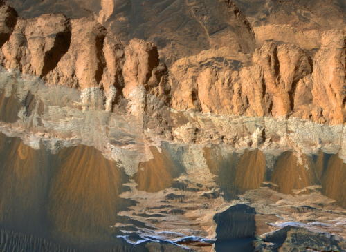
This observation shows erosional features on light-toned rocks in Aram
Chaos, a crater near the equator of Mars that has been nearly filled with
sedimentary rocks.
In enhanced color, the sediments are very distinctive.
The rocks show a sharp change in color partway down the slope, indicating a
change in the properties of the rock, probably to a different
composition.
The erosional features have alcoves with aprons downslope,
and in some cases have hints of channels, potentially due to abrasion by falling
debris. These morphologies bear some resemblance to gullies commonly found in
the mid-latitudes, which are often thought to have formed due to erosion by
liquid water from melting snow. Near the equator, however, snowmelt in Mars'
recent climate is less likely.
Image Credit: NASA/JPL-Caltech/University of Arizona (04.01.2012)
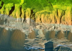
This unnamed impact crater is about 8 kilometers in diameter and contains
numerous gullies. A bright deposit was found to form on the lower slopes of one
of them in recent time. Scientists questioned whether this was an indication of
liquid water or dry materials (sand) flowing down the side of the crater. After
analysis, the presence of liquid water in this flow event cannot be ruled out,
but the available evidence is consistent with a dry granular flow.
Image Credit: NASA/JPL-Caltech/University of Arizona HiRISE Science Team
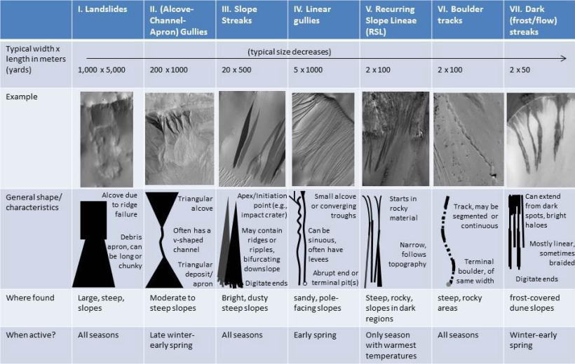
As on the Earth, many processes can move material down a Martian slope. This
graphic compares seven different types of features observed on Mars that appear
to result from material flowing or sliding or rolling down slopes.
Processes that explain one type of downslope feature may be irrelevant to
another type. Some processes depend on the presence of a fluid, some are driven
by seasonal changes in the environment, and others occur randomly when gravity
is able to pull down unstable slope material.
These different processes can generate a wide range of feature shapes, though
sometimes different processes can yield similar-looking results. Thus, to figure
out how a feature may have formed, more must be considered than its shape. For
example, researchers examining images from Mars orbiters have found differences
in
1. the season when the features are formed or are active (e.g., the
features called "recurring slope lineae" or RSLs appear
during late
spring and summer, but linear gullies are active only during early
spring);
2. the features' sizes (e.g., slope streaks can extend for miles
or kilometers, but dark frost streaks on dunes extend only up to
100
yards, or meters); and
3. the types of terrain on which a feature is found
(e.g., gullies with an alcove-channel-apron shape are found both on
rocky
slopes and on sandy slopes, but linear gullies are only found on
sandy slopes; dark frost streaks are formed on frozen dune
slopes, but
RSLs are formed on dark, warm slopes).
Scientists consider all of these factors -- and more -- when trying to form a
complete picture about a feature's formation history and in figuring out what
the presence of that feature means about the environment.
The seven images of different types of downslope features come from three
different NASA Mars orbiters. The image of a landslide comes from the Thermal
Emission Imaging System (THEMIS) on NASA's Mars Odyssey. The images of
alcove-channel-apron gullies and of slope streaks come from the Mars Orbiter
Camera (MOC) in NASA's Mars Global Surveyor. The other images come from the High
Resolution Imaging Science Experiment (HiRISE) on NASA's Mars Reconnaissance
Orbiter.
The University of Arizona, Tucson, operates THEMIS. Malin Space Science
Systems, San Diego, operated MOC. The University of Arizona, Tucson, operates
HiRISE. NASA's Jet Propulsion Laboratory, a division of the California Institute
of Technology in Pasadena, has managed the Mars orbiter projects for NASA's
Science Mission Directorate, Washington.
NASA's Mars rover Curiosity heads on the long journey to the mission's main destination, Mount Sharp
Trek to Mount Sharp Begins
Hi, I am Jeff Biesiadecki, a rover planner and flight software developer, and this is your Curiosity rover report.
After busily exploring the Glenelg region of Gale Crater,
Curiosity is moving on. The rover is starting a 5 mile, or about an 8 kilometer trek southwest towards the foothills of Mt Sharp.
Last fall, we found a great path into Glenelg. Now, we’re going back the same way, so we can quickly be on our way.
Here is a view of our recent sol 327 drive. We’re looking westward from above Glenelg, where you can see our inbound and outbound tracks.
And here is a look of that drive displayed on terrain meshes created from Curiosity's stereo navigation cameras. A terrain mesh is a 3-D representation of the ground.
This was a 40-meter long "directed drive". That’s when we tell Curiosity to just drive towards the day's goal without stopping along the way to look for and avoid hazards. 40 meters is about as far as the NAVCAM terrain meshes can reach.
The orange lines show the path that the front wheels will take and the red marks show where individual arc and turn commands will be started.
The green box shows the "corral" given to Curiosity as part of her drive plan. She will not go outside it. The red and white marker shows the goal location.
Images and animations like these are how rover planners document and present our drives for the rest of the team each day. This directed-driving mode is how we’ll start each of our drives to Mt. Sharp.
To extend our drives further, we’ll use the autonomous navigation mode
that was part of Curiosity's recent software update. It enables Curiosity
to decide on her own when to periodically stop and image the terrain in
front of her. She can then look out for large rocks and ditches and drive
around them. Using this mode, we hope to cover at least 100 meters per
day.
Here’s a map view of our upcoming drive. We expect to get one final good look at the tracks laid down last year. Curiosity should end this drive as seen in the orange path, just south of the older tracks. And meanwhile, Curiosity's odometer is close to reaching the 1 km mark! Just a couple more drives should do it.
This has been your Curiosity rover report. Please check back for more updates.
Mars in a Minute: What Happens When the Sun Blocks our Signal?
PASADENA, Calif. - The positions of the planets next month will mean
diminished communications between Earth and NASA's spacecraft at Mars.
Mars will be passing almost directly behind the sun, from Earth's
perspective. The sun can easily disrupt radio transmissions between the two
planets during that near-alignment. To prevent an impaired command from reaching
an orbiter or rover, mission controllers at NASA's Jet Propulsion Laboratory,
Pasadena, Calif., are preparing to suspend sending any commands to spacecraft at
Mars for weeks in April. Transmissions from Mars to Earth will also be
reduced.
The travels of Earth and Mars around the sun set up this arrangement, called
a Mars solar conjunction, about once every 26 months.
"This is our sixth conjunction for Odyssey," said Chris Potts of JPL, mission
manager for NASA's Mars Odyssey, which has been orbiting Mars since 2001. "We
have plenty of useful experience dealing with them, though each conjunction is a
little different."
The Mars solar conjunctions that occur once about every 26 months are not
identical to each other. They can differ in exactly how close to directly behind
the sun Mars gets, and they can differ in how active the sun is. The sun's
activity, in terms of sunspots and solar flares, varies on a 22-year cycle.
-----------
JPL, a division of the California Institute of Technology, manages the
projects operating both NASA Mars orbiters and both Mars rovers for NASA's
Science Mission Directorate, Washington.
2013-108
Guy Webster 818-354-6278
Jet Propulsion Laboratory, Pasadena, Calif.
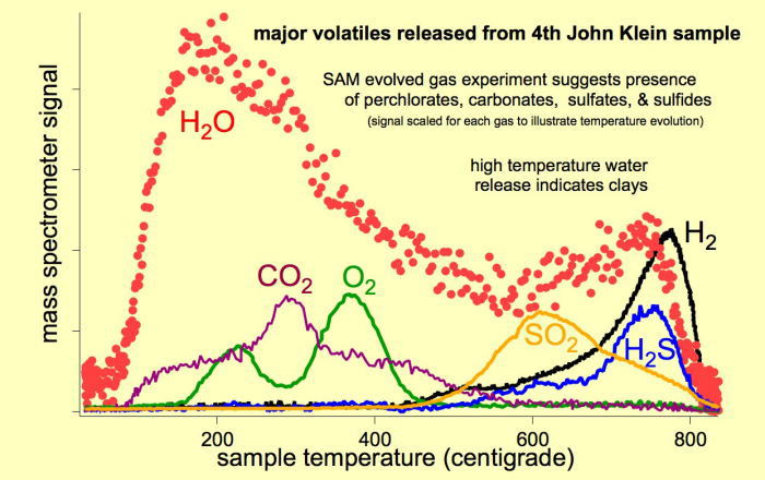
Major Volatiles Released from the Fourth 'John Klein' Portion
As the Sample Analysis at Mars (SAM) suite of instruments on NASA's Curiosity
Mars rover heats a sample, gases are released (or "evolved") from the sample and
can be identified using SAM's quadrupole mass spectrometer. This graphic shows
the principal gases evolved from the fourth portion of powder delivered to SAM
from the sample material collected when Curiosity first drilled into the "John
Klein" target rock in the "Yellowknife Bay" area of Mars' Gale Crater.
The mass spectrometer signal is scaled separately for each gas so that
the same graph can illustrate the patterns for various gases showing what
temperatures caused the gas to be released. These evolved gases and the
temperatures at which they evolved suggest the presence of hydrated minerals,
carbonates, perchlorates, sulfates and sulfides, and clays in the rock-powder
sample.
Credit: NASA/JPL-Caltech
(2013/04/12)
イエローナイフベイの地下の水分変化
地表からわずか地下10cm程度をドリルで掘削して水分保湿性を探るキュリオシティの分析調査が始まっている。ゲイルクレーター内イエローナイフベイエリアのスポット39とスポット40の下図円内の土壌領域において、Thermal/Epithermal neutrons ratio という方法で浅熱中性子比率0.8~1.4の割合で折線グラフにしているのが下図右上のものだ。どうやら#39と#40とでは、#40の方が若干水分保湿性がうわまわっているものとみられ、#40が2%-2.9%というものらしい。とは言うものの、2%台とは厳密にいうなら、火星の表面は98%が冷たく乾いているということだ。大気は95%が二酸化炭素で占められていて、酸化鉄で覆われた荒野の大地と玄武岩質の岩石や硫酸塩鉱物が堆積した地表を微かなメタンの気体が漂う表土に、キュリオシティは故障期間から回復して再び探査を続けている。火星で地道な解析作業の仕事を実に全うしているキュリオシティには、日本からも国民栄誉賞を与えてあげよう。
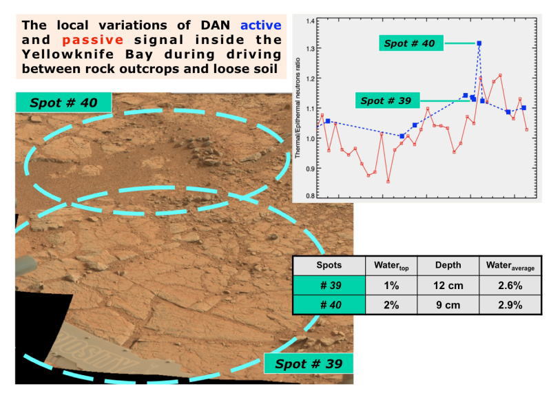
Variation in Subsurface Water In 'Yellowknife Bay'
The image, at lower left, is annotated to show where the Dynamic Albedo
of Neutrons (DAN) instrument on NASA's Mars rover Curiosity took measurement
on a rock outcrop (Spot 39) and on loose soil (Spot 40) within the "Yellowknife
Bay' area of Mars' Gale Crater.
The graph, at upper right, and the table, at lower right, show that the
DAN measurements indicated more water in the subsurface at the loose-soil
spot than at the rock outcrop. DAN detects even very small amounts of water
in the ground beneath the rover, primarily water bound into the crystal
structure of hydrated minerals.
The image at lower left was taken by the rover's Mast Camera (Mastcam).
Image credit:
NASA/JPL-Caltech/MSSS/Russian Space Research Institute